

Abstract
Two locations where slope instabilities have damaged state roads are described. These locations were investigated by geotechnical testing and the numerical analysis was carried out. The existing condition of the two locations was first analyzed and then models with possible technical solutions for remedial works. These solutions were considered from the economic and technical points of view, and the best solution was selected for the design of remedial works.
1. Introduction
An instability of the road embankment occurred on the access ramp to the relief channel Kupa–Kupa at the state road D-36. The length of the road on which significant damages were noticed is approximately 200 meters. On the connection with the relief channel the road embankment is 7,0 meters high. Damages were seriously affecting the safety of traffic and it was necessary to perform remedial works.
On the state road D-31, near the village Kravarsko, an instability of the road, about 100 meters long, occurred. The cause of instability was the activation of a landslide on the slope along the road. This landslide was activated before the year 1990 and attempts for its remedial failed in 1995, so it spread. The area affected by active sliding is approximately 2,5×10⁴ m2, and the displacements of the sliding mass are 2 – 4,5 meters.
Critical parts of the road were examined in detail on both locations. The program of geotechnical investigation was based on visual examinations.
2. Geotechnical investigation
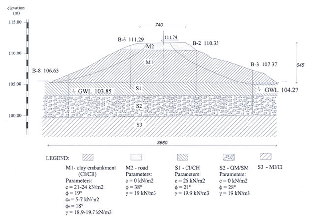
Similar geotechnical investigations were carried out on both locations. On the location of the access ramp to the relief channel Kupa-Kupa, eight boreholes were drilled to the average depth of 7,0 meters. The groundwater level was monitored and its fluctuations were registered.
On the location of the landslide near the village Kravarsko, seven boreholes were drilled to the depths of 5,0 to 16,0 meters. Two investigation pits, each 5,0 meters deep, were also excavated on this location. Piezometers were placed in five boreholes to monitor the groundwater changes.
The continuous soil identification and classification was performed in situ. Standard penetration tests were also performed in the boreholes. Disturbed and undisturbed soil samples were taken for laboratory testing.
Standard soil parameters were determined in laboratory tests. The tests were carried out for classification purposes (natural water content, natural and dry unit weight, Atterberg limits, grain size distribution), and shear strength parameters were determined on undisturbed samples.
Figure 1. Soil profile on the location of the access ramp to the relief channel Kupa-Kupa
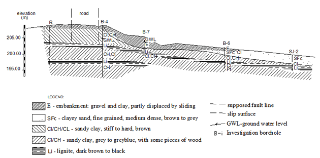
Figure 2. Soil profile on the location of the landslide near the village Kravarsko
The results of in situ and laboratory tests gave soil profiles presented in Figures 1 and 2 for the two locations.
3. Soil models and stability analysis
The same types of analyses were carried out for both locations. Based on the results of geotechnical investigations (soil profile, shear strength parameters, water table and other data) the soil model was made and the slope stability analyses were carried out.
The existing state of the slope was first analyzed. This analysis was intended for the confirmation of the soil strength parameters. The values of the angle of shearing resistance determined in laboratory testing were used, along with the correlation between the plasticity index and the residual angle of shearing resistance (Skempton 1985). For the chosen value of the residual angle of shearing resistance, the value of cohesion was determined for the slip line with the factor of safety equal to 1,0.
The results of the stability analysis are presented in Figures 3 and 4 for the existing conditions on the two locations. Figures 5 and 6 show some of the results on the models, which include remedial measures.
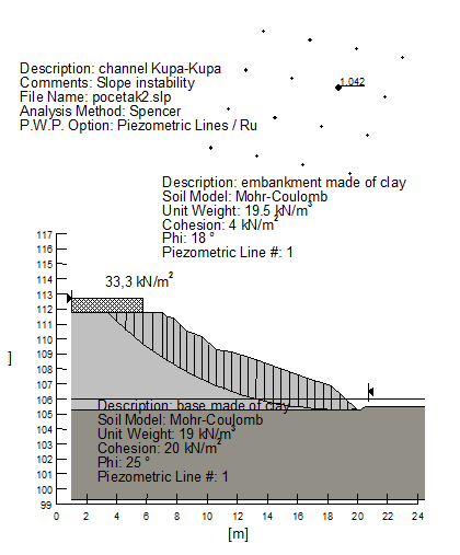
Figure 3. Stability analysis for the condition before remedial works on the access ramp
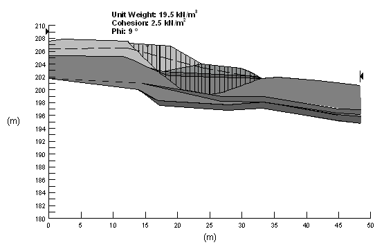
Figure 4. Stability analysis for the condition before remedial works on the landslide
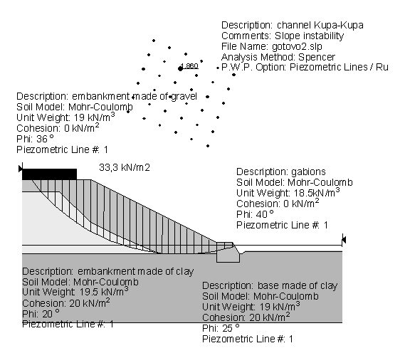
Figure 5. Stability analysis for the condition after remedial works on the access ramp
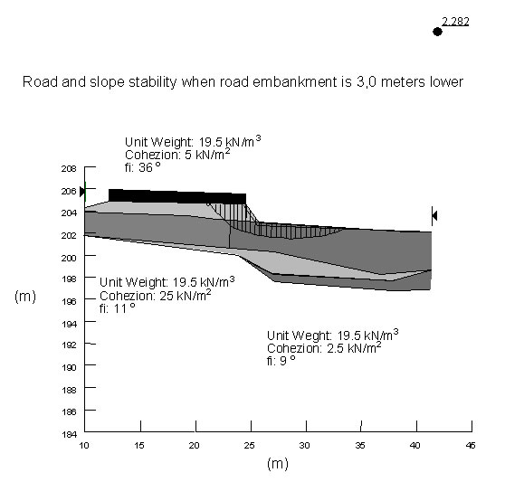
Figure 6. Stability analysis for the condition after remedial works on the landslide
4. Analyzed solutions
Several technical solutions were analyzed for remedial works on the two destabilized locations. The selected solutions were based on the technical, financial and ecological aspects, in agreement with the client.
4.1 Access ramp to the relief channel Kupa-Kupa
The stabilization of the unstable embankment and the road could be achieved by alterations that would improve the strength characteristics of the embankment material and/or by applying additional horizontal forces to the retaining structure that would increase the factor of safety against sliding. The analyzed technical solutions were as follows.
The first alternative is to change the destabilized clay material with gravel and to construct a gabion wall at the toe of the embankment to further stabilize it. Drainage canals for surface and seepage water are provided on the slopes and by the gabions. The road is then reconstructed. In order to prevent settlements of the clay embankment due to the traffic load, a geomembrane and geotextile is used under the road structure.
The second analyzed solution includes pile walls constructed along the sides of the road. These pile walls, which are 10,0 m apart, are connected by anchors to take account of the horizontal forces arising from the destabilized slope. The anchors are installed 2,5 m under the road surface, and thus, have to be protected against corrosion. The slope inclination has to be decreased. The drainage canals are constructed on the slopes and by the embankment toe. The road structure is placed on a geomembrane and geotextile, as for the first alternative.
The first alternative was selected. The characteristic cross-section of this solution is shown in Figure 7.
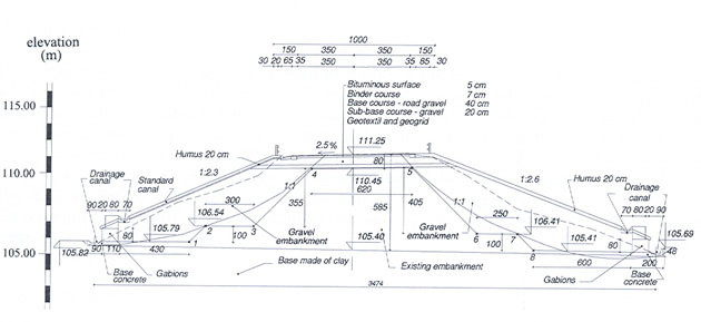
Figure 7. Remedial works by changing the embankment material and constructing a gabion wall
4.2 Landslide near the village Kravarsko
Two solutions were analyzed for securing the stability of the road on the slope affected by the landslide near the village Kravarsko. The first alternative was to reduce significantly pore water pressures in the ground and to apply the additional load to the slope by constructing the embankment and the road. The second alternative was to transfer the embankment and road loads deeper into the ground to the supporting layers.
The first alternative includes the excavation of the road embankment in the length of approximately 230 meters. The height of the excavated embankment is 3,0 meters in the landslide zone. Such unloading of the slope will increase the longitudinal inclination of the road vertical alignment. The quality of traffic on this part of the road will be reduced, but the road would still remain within the permissible boundaries for this category. It is also necessary to construct the drainage system for surface and seepage water and to arrange the slope surface beneath the road. These remedial works will ensure the stability of the part of the slope where the road is located, thus ensuring safe traffic.
In the other alternative, the vertical alignment and other elements of positioning the road are not changed. The road embankment is constructed on the supporting structure, which is founded in deep supporting layers of the ground by using bored reinforced concrete piles. A part of the supporting structure is founded under the second layer of lignite and a part in the layer of sand. The embankment is 4,0 m high. The piles are approximately 12,0 m long, with a diameter of 0,40 m. Their axes are about 1,0 m apart along the road. The total length of this structure is approximately 200,0 m.
The first alternative was selected. The characteristic cross-section of this solution is shown in Figure 8.
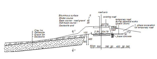
Figure 8. Remedial works by unloading the slope and constructing a drainage system
5. Conclusion
Two examples, which show the analyzed alternatives for remedial works, and the selected solutions for two unstable slopes, are described in the paper. The sequence of undertaken activities is also described. The geotechnical investigation included geodetic surveying and visual inspection of the locations, in situ boreholes and investigation pits, as well as in situ and laboratory tests. Numerical analyses were carried out on several models with the suggested solutions for remedial works in order to assess the improved stability of the slopes. The selected technical solutions had to provide satisfactory results with an acceptable cost. The continuity of traffic had to be achieved during remedial works and the works had to be completed in the planned period.
6. Reference
Skempton, A. W. 1985. Residual strength of clays in landslides, folded strata and the laboratory.
Geotechnique 35(1): 3-18.
Autor: O. Sorić, Geotechnical studio, Zagreb, Croatia